For the last few weeks I have been streaming on Friday night from 8:00 pm – 10:00 pm on Twitch.
I had an idea a year or so ago to make a campaign world setting to hold all of my convention scenarios – the game ideas I come up with and run at conventions. All of my fantasy genre settings will be here that I made and ran in AD&D (2), DCC (1), and Delving Deeper (5 with one nearly written for UCon in November and another idea for next year), ten total. I’ve run various games across five conventions (UCon, Gary Con, Marmalade Dog, and Gamehole Con). It’s five if you count virtual Gary Con during Covid as a separate convention.
The plan is to convert the AD&D and DCC scenarios to Delving Deeper so that my campaign world is homogenous. I also plan to locate my old Delving Deeper Roll20 campaign in this world, and a campaign idea with some notes.
What Is This New World?
My inspired idea is to make a world composed of islands and archipelagos spread across an ocean world. No continents, no island larger than Greenland (1,600 miles x 800 miles).
I have been researching and gathering information about islands, archipelagos, and the kinds of things I will need tables to help generate the details of each island.
Between each Friday’s stream, I do a bit more on different aspects.
Tonight, during my stream, I had an idea that made it come together, and I finally feel like I have a solid outline/framework with which to proceed.
Steps To Insight
I started gathering some distance information on different islands and archipelagos before my stream. I got the length and width of Greenland and compared it to the distance from New York, New York to Kansas City, Missouri, and Greenland is longer than that.
Greenland is disputed in its widest point, but most claim it is 650 miles wide which is a bit further than the distance from Kalamazoo, Michigan to Kansas City, Missouri. From were I live now to where I grew up and my brothers still live.
The Indonesian archipelago is longer than the continental U.S. is wide.
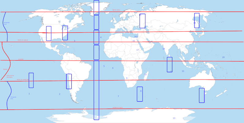
I then got a map of the world and placed lines for the equator, tropics, and the Arctic and Antarctic circles.
Then I figured how many Greenlands laid lengthways would go around the Earth, and the same with the Indonesian archipelago.
Greenland is about 1,660 miles from North to South
It is disputed whether it is 650 to 800 miles
East to West, but 650 miles is the most often cited.
The Indonesian archipelago is about 3,181 miles
east to west and about 1,094 miles north to south.
New York, New York to Kansas City, Missouri is
about 1,190 miles.
This is less than half of twice the width of Greenland,
and about 470 shorter than the length of Greenland.
New York to Los Angeles, California is about 2,790 miles,
about 1,100 miles longer than Greenland.
This makes the span of Indonesia east to west about
390 miles wider than the U.S.
Circumference of Earth is about 25,000.
North Pole to Equator & Equator to South Pole approx.
12,500
12,500/3,181 (E to W length of Indonesian Arch.) = c. 4 (3.93)
4 Indonesian archipelagos would span half the Earth, so
8 needed to go all the way around.
12,500 / 1,094 (N. to S. of Ind. Arch.) = 11.43
11 widths of Indonesia half the Earth, 22 for all the way.
Greenland length 12,500 / 1,660 = 7.5
15 to go all the way around.
One could easily have 10 or 12 Greenland sized islands spread over a planet and none would see each other or be within a “quick” trip or “short” journey across the seas.
The method and technology of navigation would limit the likelihood of one discovering another.
However, a world with so little land might encourage more exploration rising up like it did with the Polynesian navigators that used memorized star charts, ocean currents, and paying attention to changes in currents and wind and weather.
I then drew a rectangle about the rough dimensions of Greenland and made a line from North to South for eight such rectangles.
I then placed ten of them around my global map and it made it clear that ten or twelve such islands would have plenty of space to never see another big island without travelling within sight of it.
Next I brainstormed some ideas to generate islands and archipelagos for their relative placement on a map.
Methods to generate relative placement of each island or archipelago.
1.) Grab 12-15 d6s and do the die drop on a hex map method.
2.) Use rice, beans, etc. covering a hex map and move them aside for the oceans, the rice or beans piled up for the elevation of the islands.
3.) Use an online generator or downloadable mapping tool that has a utility for generating islands and archipelagos.
4.) Use a world map of Earth and randomly make land into islands, or pick interesting coastlines to mash together into an island.
4a.) Usa a topographic map of Earth and use a random topographic elevation point as the coast.
5.) Use maps of Mars, etc.
6.) Use other fictional maps/rpg maps to get the idea. (Avoid Trademark & Copyright infringement.)
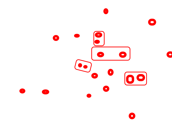
20d6 – Die Drop on Floor for Relative Placement.
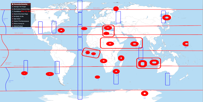
As with most gamers, I have a lot of d6s. I have about 40d6 of various colors in a sandwich bag. I counted out 20 and figured I could drop them on my carpet so they wouldn’t bounce and roll too far and not under furniture.
Some of them were the same color. I had roughly equal handfuls so they wouldn’t all be in the middle and dropped them. Naturally, some were outliers around the edge and others tended to be nearer. If dice of the same color were near (about 6 inches apart) I considered them somehow related. Whether that is by geology, politics, trade, or something else is to be determined.
I then took a picture of the dice on the floor with my cell and emailed it to myself to get it on my PC. I opened the image in Paint.Net and put a red circle around the location of each die, and drew a red rectangle around the coincidental pairs of same colored dice. Finally, I added this as a layer to my world map in Paint.net.
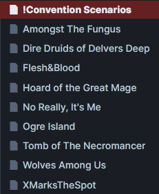
Then I numbered each circle, then I added a screenshot from my Obsidian Vault for this project listing the names of all of my convention scenarios (some might say modules).
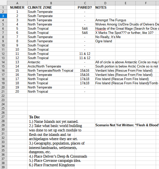
I created a new spreadsheet and made four columns: The number of the island(s) on the map, the zone (Arctic, Temperate, Tropical, or Antarctic), Paired Dice, and Notes listing the names of convention scenario(s) on that island.
Finally, I added a text insert with a To Do List.
So What’s Next?
The rough world map and the spreadsheet with notes tying it together is the framework I needed to guide this whole thing.
One part is preparing scenarios to publish on DriveThru RPG, or revising the ones already published. I will take the minimal worldbuilding elements presented in the scenarios and both flesh them out and tie them to a location in this world.
The other part is continuing to collect information to build tables to help inspire me or move me past anything that might block me from making an interesting and well put together setting.
It will be both a campaign world and a supplement to aid others with world building with a specific emphasis on sea based settings for generating islands, archipelagos, and ocean encounters and adventures.
One idea was for a “Sea Marches” campaign inspired by the West Marches style of campaign. I’m not sure how well that would work for a pure West Marches style campaign, but it would definitely work for an ocean based island hopping hexcrawl.
What About The Card Game?
Preliminary art is still coming in from the artist I contracted and it looks awesome! I’m limited on what I can do until the art is ready to place in the layout and order a test print from DriveThru Cards.
I’ll be working on the Kickstarter soon enough to get it ready for launch in October.
Until then, I’m getting a jump on this idea while I have the energy and motivation to do it.
But What About The Scenario For UCon in November?
I submitted my game last week and have the outline of the adventure done. I just need to fill in the details and add the descriptions to make this adventure ready to run. I don’t need that much to be able to run a game. I’ve run games with surprisingly little prep in the past. But I have a mind to publish my adventures, so I put a lot more effort in.
I’m getting a lot of things done now that I’m sticking to my guns and not working past quitting time at the day job. They are no longer getting the bulk of my energy, creativity, and enthusiasm since it was made clear to me that my efforts don’t really matter. Rather than be miserable, I’m having fun creating and getting in the right mindset to start running games again.
I’ve got a lot of projects around the house to wrap up before that happens, but those are also coming along nicely.
I’d love to run something on a weekly or bi-weekly basis at the FLGS, but want to be realistic. I’m also toying with a new campaign idea on Roll20 for a West Marches style game. It’s the same idea that I’d do at the FLGS. I haven’t been in there but once since they moved across the street. I haven’t run a game there since a year or two pre-Covid.
The ideas are just flowing faster than I can write them down or make sense of how to implement them. I love that state of creativity. It is energizing and renewing and fun! We all need more fun in our lives, especially with the state of the world.