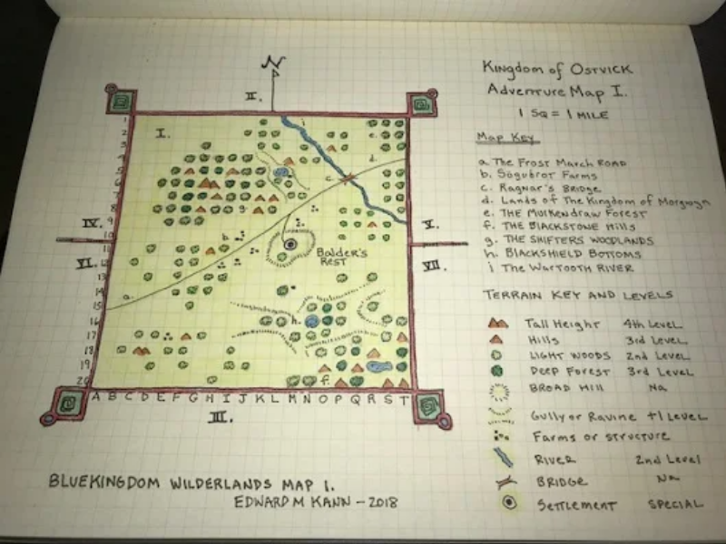
Edward Kann posted a map of an area in his Blueholme game he started with his sons. (Check out his G+ profile, he has some serious talent for maps and adventure design.) He has mapped the contents of a 20 mile hex using graph paper for the scale of 1 square per mile. One can debate the changing of scale for accuracy between hexes and squares ad nauseum. Forget that noise. The cool thing is the map key has a section for a TERRAIN KEY with LEVELS for each type of terrain.

My Plan For This.
I like this idea for levels for terrain. I’ll modify that for my own use with a keep, town, or city within so many miles. Say a keep with a 20 mile radius zone of control would negate bad/evil/monstrous encounters. (This is basically the West Marches approach.)
However, wild animals would always be a possibility. Sick or wounded animals would be more likely to attack. Males of most species in mating season would be more likely to attack. Mothers protecting young would be more likely to attack. So lack of monsters does not mean “no danger.”
The deep forest being 3rd level is cool. I’ll add a dark wood more focused on the bad things in the forest. That is, a dark wood would have an encounter table focused on the bad/evil creatures found in forests.
For my purposes, I want a variation for the farms/structures. Have a special set of tables to determine if it is a farm or other structures, their condition – ruins, burnt out/smoldering, etc. And finally if occupied by farmers or otherwise the “correct” occupants or “something else.” Something else could be a hungry monster, goblin raiding party, house or barn fire, etc. A large animal in mating season being belligerent, whether a wild animal or the bull got loose.
This is what I love about the OSR and sharing RPG ideas for any game online. All the different people with their unique take on how they do things spark ideas for how I can use and modify their ideas for my own use.

